|
|
|||||||||||||||||
| Point ID: 5587 | Downloads | Plots | Site Data | Code: 06CA003 |
|
|
|||||||||||||||||
| Download | |
|---|---|
| Site Descriptor Information | Site Time Series Data |
| Link to all available data | |
| View: | Time Series | All |
| Units: | m3/s |
| Statistic | Jan | Feb | Mar | Apr | May | Jun | Jul | Aug | Sep | Oct | Nov | Dec | Annual |
|---|---|---|---|---|---|---|---|---|---|---|---|---|---|
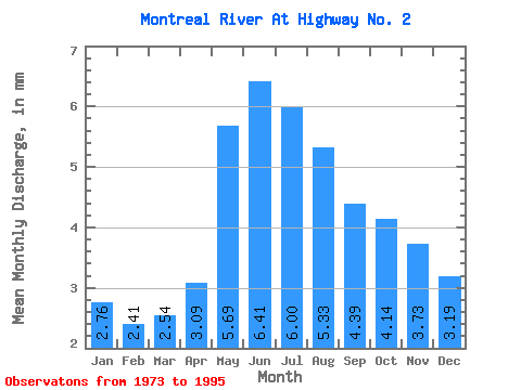
| Mean | 2.76 | 2.43 | 2.54 | 3.09 | 5.69 | 6.41 | 6.00 | 5.33 | 4.39 | 4.14 | 3.73 | 3.19 | 47.24 |
| Standard Deviation | 3.00 | 2.60 | 2.67 | 2.49 | 4.19 | 5.35 | 6.48 | 6.67 | 6.11 | 5.82 | 5.03 | 4.10 | 45.68 |
| Min | 0.00 | 0.00 | 0.00 | 0.07 | 0.18 | 0.21 | 0.72 | 0.23 | 0.07 | 0.03 | 0.01 | 0.00 | 6.73 |
| Max | 12.53 | 10.65 | 10.76 | 9.99 | 17.79 | 19.02 | 23.88 | 23.83 | 22.54 | 22.41 | 19.17 | 14.30 | 195.30 |
| Coefficient of Variation | 1.09 | 1.07 | 1.05 | 0.81 | 0.74 | 0.83 | 1.08 | 1.25 | 1.39 | 1.41 | 1.35 | 1.29 | 0.97 |
 Return to R-Arctic Net Home Page