|
|
|||||||||||||||||
| Point ID: 5586 | Downloads | Plots | Site Data | Code: 06CA001 |
|
|
|||||||||||||||||
| Download | |
|---|---|
| Site Descriptor Information | Site Time Series Data |
| Link to all available data | |
| View: | Time Series | All |
| Units: | m3/s |
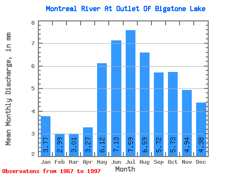
| Statistic | Jan | Feb | Mar | Apr | May | Jun | Jul | Aug | Sep | Oct | Nov | Dec | Annual |
|---|---|---|---|---|---|---|---|---|---|---|---|---|---|
| Mean | 3.77 | 3.02 | 3.01 | 3.27 | 6.12 | 7.13 | 7.58 | 6.59 | 5.72 | 5.73 | 4.94 | 4.38 | 60.97 |
| Standard Deviation | 2.78 | 2.34 | 2.41 | 2.54 | 4.24 | 4.26 | 5.73 | 5.32 | 5.10 | 4.83 | 3.90 | 3.23 | 42.24 |
| Min | 1.08 | 0.72 | 0.50 | 0.61 | 0.53 | 0.20 | 0.57 | 1.19 | 1.32 | 1.60 | 1.61 | 1.42 | 13.37 |
| Max | 13.87 | 12.03 | 12.98 | 13.96 | 21.48 | 18.98 | 21.19 | 20.78 | 20.83 | 21.78 | 18.12 | 15.60 | 196.02 |
| Coefficient of Variation | 0.74 | 0.78 | 0.80 | 0.78 | 0.69 | 0.60 | 0.76 | 0.81 | 0.89 | 0.84 | 0.79 | 0.74 | 0.69 |
 Return to R-Arctic Net Home Page