|
|
|||||||||||||||||
| Point ID: 5573 | Downloads | Plots | Site Data | Code: 06AE001 |
|
|
|||||||||||||||||
| Download | |
|---|---|
| Site Descriptor Information | Site Time Series Data |
| Link to all available data | |
| View: | Time Series | All |
| Units: | m3/s |
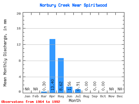
| Statistic | Jan | Feb | Mar | Apr | May | Jun | Jul | Aug | Sep | Oct | Nov | Dec | Annual |
|---|---|---|---|---|---|---|---|---|---|---|---|---|---|
| Mean | 0.12 | 5.27 | 3.39 | 0.61 | 0.36 | 0.00 | 0.00 | 0.00 | |||||
| Standard Deviation | 0.36 | 7.72 | 5.46 | 1.66 | 1.41 | 0.00 | 0.00 | 0.01 | |||||
| Min | 0.00 | 0.00 | 0.00 | 0.00 | 0.00 | 0.00 | 0.00 | 0.00 | |||||
| Max | 1.42 | 32.34 | 19.16 | 6.72 | 6.00 | 0.01 | 0.00 | 0.03 | |||||
| Coefficient of Variation | 2.98 | 1.46 | 1.61 | 2.71 | 3.92 | 4.24 | 4.24 |
 Return to R-Arctic Net Home Page