|
|
|||||||||||||||||
| Point ID: 5572 | Downloads | Plots | Site Data | Code: 06AD011 |
|
|
|||||||||||||||||
| Download | |
|---|---|
| Site Descriptor Information | Site Time Series Data |
| Link to all available data | |
| View: | Time Series | All |
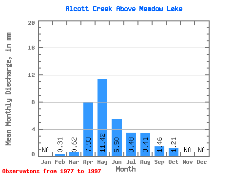
| Units: | m3/s |
| Statistic | Jan | Feb | Mar | Apr | May | Jun | Jul | Aug | Sep | Oct | Nov | Dec | Annual |
|---|---|---|---|---|---|---|---|---|---|---|---|---|---|
| Mean | 0.32 | 0.62 | 7.93 | 11.41 | 5.50 | 3.48 | 3.41 | 1.46 | 1.21 | ||||
| Standard Deviation | 0.51 | 6.30 | 10.21 | 6.41 | 4.19 | 8.31 | 2.37 | 1.11 | |||||
| Min | 0.32 | 0.12 | 1.15 | 0.55 | 0.24 | 0.03 | 0.05 | 0.01 | 0.10 | ||||
| Max | 0.32 | 2.16 | 28.35 | 35.41 | 26.17 | 13.52 | 37.08 | 7.60 | 4.25 | ||||
| Coefficient of Variation | 0.81 | 0.80 | 0.90 | 1.17 | 1.21 | 2.44 | 1.63 | 0.92 |
 Return to R-Arctic Net Home Page