|
|
|||||||||||||||||
| Point ID: 5552 | Downloads | Plots | Site Data | Code: 05ND001 |
|
|
|||||||||||||||||
| Download | |
|---|---|
| Site Descriptor Information | Site Time Series Data |
| Link to all available data | |
| View: | Time Series | All |
| Units: | m3/s |
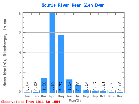
| Statistic | Jan | Feb | Mar | Apr | May | Jun | Jul | Aug | Sep | Oct | Nov | Dec | Annual |
|---|---|---|---|---|---|---|---|---|---|---|---|---|---|
| Mean | 0.01 | 0.03 | 0.49 | 2.58 | 1.88 | 0.44 | 0.26 | 0.08 | 0.06 | 0.07 | 0.03 | 0.02 | 6.24 |
| Standard Deviation | 0.03 | 0.06 | 0.88 | 4.61 | 3.32 | 0.72 | 0.45 | 0.10 | 0.10 | 0.10 | 0.04 | 0.03 | 8.98 |
| Min | 0.00 | 0.00 | 0.00 | 0.01 | 0.01 | 0.00 | 0.00 | 0.00 | 0.00 | 0.00 | 0.00 | 0.00 | 0.02 |
| Max | 0.13 | 0.27 | 3.89 | 22.40 | 13.45 | 3.23 | 2.01 | 0.37 | 0.41 | 0.41 | 0.17 | 0.15 | 35.37 |
| Coefficient of Variation | 2.06 | 2.21 | 1.80 | 1.79 | 1.76 | 1.64 | 1.71 | 1.33 | 1.72 | 1.46 | 1.26 | 1.59 | 1.44 |
 Return to R-Arctic Net Home Page