|
|
|||||||||||||||||
| Point ID: 5538 | Downloads | Plots | Site Data | Code: 05NB026 |
|
|
|||||||||||||||||
| Download | |
|---|---|
| Site Descriptor Information | Site Time Series Data |
| Link to all available data | |
| View: | Time Series | All |
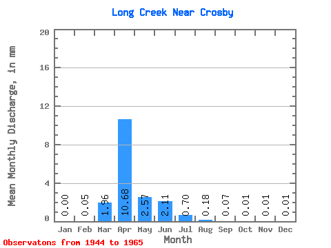
| Units: | m3/s |
| Statistic | Jan | Feb | Mar | Apr | May | Jun | Jul | Aug | Sep | Oct | Nov | Dec | Annual |
|---|---|---|---|---|---|---|---|---|---|---|---|---|---|
| Mean | 0.00 | 0.02 | 0.73 | 3.99 | 0.96 | 0.79 | 0.26 | 0.07 | 0.03 | 0.01 | 0.00 | 0.00 | 6.42 |
| Standard Deviation | 0.00 | 0.08 | 1.39 | 5.86 | 1.83 | 1.66 | 0.67 | 0.18 | 0.06 | 0.03 | 0.01 | 0.01 | 7.05 |
| Min | 0.00 | 0.00 | 0.00 | 0.00 | 0.00 | 0.00 | 0.00 | 0.00 | 0.00 | 0.00 | 0.00 | 0.00 | 0.00 |
| Max | 0.01 | 0.38 | 5.84 | 25.54 | 6.87 | 6.50 | 2.93 | 0.82 | 0.23 | 0.12 | 0.07 | 0.03 | 28.90 |
| Coefficient of Variation | 3.16 | 4.57 | 1.89 | 1.47 | 1.90 | 2.11 | 2.58 | 2.70 | 2.37 | 4.40 | 4.06 | 3.11 | 1.10 |
 Return to R-Arctic Net Home Page