|
|
|||||||||||||||||
| Point ID: 5518 | Downloads | Plots | Site Data | Code: 05NA003 |
|
|
|||||||||||||||||
| Download | |
|---|---|
| Site Descriptor Information | Site Time Series Data |
| Link to all available data | |
| View: | Time Series | All |
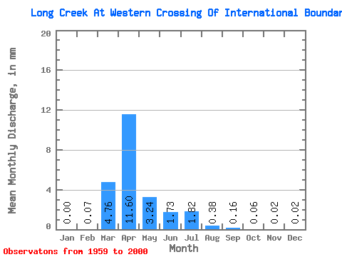
| Units: | m3/s |
| Statistic | Jan | Feb | Mar | Apr | May | Jun | Jul | Aug | Sep | Oct | Nov | Dec | Annual |
|---|---|---|---|---|---|---|---|---|---|---|---|---|---|
| Mean | 0.00 | 0.03 | 1.79 | 4.37 | 1.22 | 0.65 | 0.69 | 0.14 | 0.06 | 0.02 | 0.01 | 0.01 | 9.00 |
| Standard Deviation | 0.01 | 0.10 | 3.34 | 6.68 | 2.80 | 1.57 | 1.79 | 0.44 | 0.22 | 0.10 | 0.02 | 0.01 | 10.37 |
| Min | 0.00 | 0.00 | 0.00 | 0.00 | 0.00 | 0.00 | 0.00 | 0.00 | 0.00 | 0.00 | 0.00 | 0.00 | 0.00 |
| Max | 0.04 | 0.57 | 12.85 | 24.06 | 13.68 | 8.24 | 9.76 | 2.71 | 1.41 | 0.59 | 0.10 | 0.07 | 42.08 |
| Coefficient of Variation | 3.97 | 3.85 | 1.86 | 1.53 | 2.29 | 2.41 | 2.60 | 3.08 | 3.75 | 4.22 | 2.76 | 2.67 | 1.15 |
 Return to R-Arctic Net Home Page