|
|
|||||||||||||||||
| Point ID: 5513 | Downloads | Plots | Site Data | Code: 05MD006 |
|
|
|||||||||||||||||
| Download | |
|---|---|
| Site Descriptor Information | Site Time Series Data |
| Link to all available data | |
| View: | Time Series | All |
| Units: | m3/s |
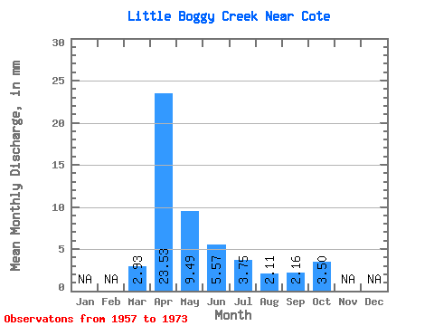
| Statistic | Jan | Feb | Mar | Apr | May | Jun | Jul | Aug | Sep | Oct | Nov | Dec | Annual |
|---|---|---|---|---|---|---|---|---|---|---|---|---|---|
| Mean | 1.50 | 12.05 | 4.86 | 2.86 | 1.92 | 1.08 | 1.10 | 1.79 | |||||
| Standard Deviation | 2.81 | 7.70 | 2.75 | 2.17 | 1.25 | 0.67 | 0.85 | 1.21 | |||||
| Min | 0.00 | 2.57 | 2.44 | 0.57 | 0.52 | 0.05 | 0.04 | 0.37 | |||||
| Max | 9.97 | 25.92 | 13.50 | 7.50 | 5.94 | 2.56 | 3.48 | 4.63 | |||||
| Coefficient of Variation | 1.87 | 0.64 | 0.56 | 0.76 | 0.65 | 0.62 | 0.77 | 0.68 |
 Return to R-Arctic Net Home Page