|
|
|||||||||||||||||
| Point ID: 5507 | Downloads | Plots | Site Data | Code: 05MB012 |
|
|
|||||||||||||||||
| Download | |
|---|---|
| Site Descriptor Information | Site Time Series Data |
| Link to all available data | |
| View: | Time Series | All |
| Units: | m3/s |
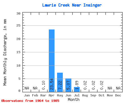
| Statistic | Jan | Feb | Mar | Apr | May | Jun | Jul | Aug | Sep | Oct | Nov | Dec | Annual |
|---|---|---|---|---|---|---|---|---|---|---|---|---|---|
| Mean | 0.06 | 13.50 | 4.15 | 2.91 | 1.08 | 0.01 | 0.01 | 0.01 | |||||
| Standard Deviation | 0.13 | 13.52 | 6.35 | 8.06 | 2.23 | 0.03 | 0.03 | 0.02 | |||||
| Min | 0.00 | 0.00 | 0.00 | 0.00 | 0.00 | 0.00 | 0.00 | 0.00 | |||||
| Max | 0.38 | 40.38 | 20.16 | 27.15 | 6.88 | 0.09 | 0.10 | 0.07 | |||||
| Coefficient of Variation | 2.06 | 1.00 | 1.53 | 2.77 | 2.06 | 2.83 | 2.19 | 2.14 |
 Return to R-Arctic Net Home Page