|
|
|||||||||||||||||
| Point ID: 5503 | Downloads | Plots | Site Data | Code: 05MB006 |
|
|
|||||||||||||||||
| Download | |
|---|---|
| Site Descriptor Information | Site Time Series Data |
| Link to all available data | |
| View: | Time Series | All |
| Units: | m3/s |
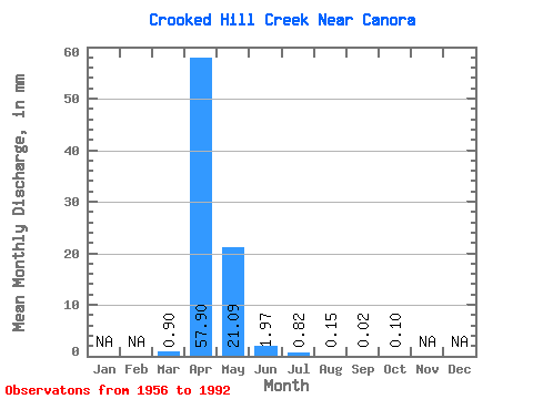
| Statistic | Jan | Feb | Mar | Apr | May | Jun | Jul | Aug | Sep | Oct | Nov | Dec | Annual |
|---|---|---|---|---|---|---|---|---|---|---|---|---|---|
| Mean | 0.16 | 10.35 | 3.77 | 0.35 | 0.15 | 0.03 | 0.01 | 0.02 | |||||
| Standard Deviation | 0.55 | 10.74 | 7.11 | 0.82 | 0.36 | 0.10 | 0.02 | 0.09 | |||||
| Min | 0.00 | 0.00 | 0.00 | 0.00 | 0.00 | 0.00 | 0.00 | 0.00 | |||||
| Max | 2.84 | 42.80 | 31.47 | 3.22 | 1.76 | 0.51 | 0.11 | 0.49 | |||||
| Coefficient of Variation | 3.37 | 1.04 | 1.89 | 2.33 | 2.47 | 3.58 | 4.09 | 5.00 |
 Return to R-Arctic Net Home Page