|
|
|||||||||||||||||
| Point ID: 5500 | Downloads | Plots | Site Data | Code: 05MB003 |
|
|
|||||||||||||||||
| Download | |
|---|---|
| Site Descriptor Information | Site Time Series Data |
| Link to all available data | |
| View: | Time Series | All |
| Units: | m3/s |
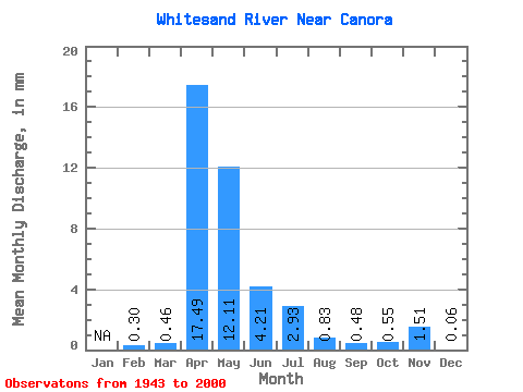
| Statistic | Jan | Feb | Mar | Apr | May | Jun | Jul | Aug | Sep | Oct | Nov | Dec | Annual |
|---|---|---|---|---|---|---|---|---|---|---|---|---|---|
| Mean | 0.07 | 0.11 | 4.00 | 2.77 | 0.96 | 0.67 | 0.19 | 0.11 | 0.13 | 0.34 | 0.01 | ||
| Standard Deviation | 0.08 | 0.18 | 4.54 | 4.70 | 2.17 | 1.35 | 0.47 | 0.30 | 0.36 | 0.62 | |||
| Min | 0.01 | 0.00 | 0.05 | 0.01 | 0.00 | 0.00 | 0.00 | 0.00 | 0.00 | 0.01 | 0.01 | ||
| Max | 0.12 | 0.91 | 22.66 | 22.86 | 14.38 | 6.22 | 2.74 | 1.92 | 2.37 | 1.28 | 0.01 | ||
| Coefficient of Variation | 1.16 | 1.66 | 1.13 | 1.70 | 2.26 | 2.02 | 2.44 | 2.79 | 2.82 | 1.81 |
 Return to R-Arctic Net Home Page