|
|
|||||||||||||||||
| Point ID: 55 | Downloads | Plots | Site Data | Code: 05AC001 |
|
|
|||||||||||||||||
| Download | |
|---|---|
| Site Descriptor Information | Site Time Series Data |
| Link to all available data | |
| View: | Time Series | All |
| Units: | m3/s |
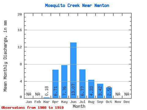
| Statistic | Jan | Feb | Mar | Apr | May | Jun | Jul | Aug | Sep | Oct | Nov | Dec | Annual |
|---|---|---|---|---|---|---|---|---|---|---|---|---|---|
| Mean | 0.18 | 6.71 | 7.76 | 13.07 | 6.76 | 4.33 | 3.42 | 2.58 | |||||
| Standard Deviation | 7.00 | 9.16 | 19.55 | 9.95 | 5.03 | 6.00 | 3.63 | ||||||
| Min | 0.18 | 0.72 | 0.69 | 0.07 | 0.00 | 0.00 | 0.00 | 0.04 | |||||
| Max | 0.18 | 21.60 | 24.93 | 53.63 | 33.14 | 15.19 | 21.40 | 13.03 | |||||
| Coefficient of Variation | 1.04 | 1.18 | 1.50 | 1.47 | 1.16 | 1.75 | 1.41 |
 Return to R-Arctic Net Home Page