|
|
|||||||||||||||||
| Point ID: 5496 | Downloads | Plots | Site Data | Code: 05MA023 |
|
|
|||||||||||||||||
| Download | |
|---|---|
| Site Descriptor Information | Site Time Series Data |
| Link to all available data | |
| View: | Time Series | All |
| Units: | m3/s |
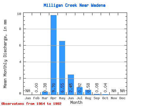
| Statistic | Jan | Feb | Mar | Apr | May | Jun | Jul | Aug | Sep | Oct | Nov | Dec | Annual |
|---|---|---|---|---|---|---|---|---|---|---|---|---|---|
| Mean | 0.00 | 0.12 | 3.15 | 2.13 | 0.80 | 0.30 | 0.19 | 0.03 | 0.01 | ||||
| Standard Deviation | 0.30 | 3.48 | 3.00 | 1.57 | 0.64 | 0.59 | 0.07 | 0.05 | |||||
| Min | 0.00 | 0.00 | 0.01 | 0.00 | 0.00 | 0.00 | 0.00 | 0.00 | 0.00 | ||||
| Max | 0.00 | 1.00 | 11.85 | 10.75 | 5.17 | 2.21 | 2.47 | 0.25 | 0.22 | ||||
| Coefficient of Variation | 2.42 | 1.10 | 1.41 | 1.97 | 2.16 | 3.10 | 2.48 | 3.82 |
 Return to R-Arctic Net Home Page