|
|
|||||||||||||||||
| Point ID: 5481 | Downloads | Plots | Site Data | Code: 05LE011 |
|
|
|||||||||||||||||
| Download | |
|---|---|
| Site Descriptor Information | Site Time Series Data |
| Link to all available data | |
| View: | Time Series | All |
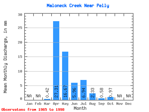
| Units: | m3/s |
| Statistic | Jan | Feb | Mar | Apr | May | Jun | Jul | Aug | Sep | Oct | Nov | Dec | Annual |
|---|---|---|---|---|---|---|---|---|---|---|---|---|---|
| Mean | 0.40 | 25.95 | 15.83 | 5.66 | 6.59 | 2.21 | 0.55 | 0.92 | |||||
| Standard Deviation | 0.65 | 18.33 | 19.12 | 7.37 | 12.21 | 5.73 | 0.90 | 1.15 | |||||
| Min | 0.00 | 0.12 | 0.06 | 0.03 | 0.00 | 0.00 | 0.00 | 0.00 | |||||
| Max | 2.72 | 64.08 | 61.74 | 28.37 | 52.37 | 25.74 | 2.98 | 4.57 | |||||
| Coefficient of Variation | 1.62 | 0.71 | 1.21 | 1.30 | 1.85 | 2.59 | 1.64 | 1.25 |
 Return to R-Arctic Net Home Page