|
|
|||||||||||||||||
| Point ID: 5478 | Downloads | Plots | Site Data | Code: 05LC002 |
|
|
|||||||||||||||||
| Download | |
|---|---|
| Site Descriptor Information | Site Time Series Data |
| Link to all available data | |
| View: | Time Series | All |
| Units: | m3/s |
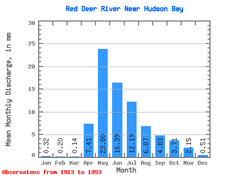
| Statistic | Jan | Feb | Mar | Apr | May | Jun | Jul | Aug | Sep | Oct | Nov | Dec | Annual |
|---|---|---|---|---|---|---|---|---|---|---|---|---|---|
| Mean | 0.25 | 0.16 | 0.11 | 5.71 | 18.36 | 12.65 | 9.41 | 5.30 | 3.72 | 2.87 | 1.66 | 0.39 | 28.15 |
| Standard Deviation | 0.34 | 0.23 | 0.14 | 3.55 | 13.90 | 12.88 | 7.53 | 4.71 | 4.51 | 3.65 | 1.14 | 0.51 | 24.02 |
| Min | 0.01 | 0.00 | 0.01 | 1.85 | 0.92 | 1.02 | 1.86 | 0.54 | 0.54 | 0.55 | 0.24 | 0.04 | 11.16 |
| Max | 0.49 | 0.32 | 0.21 | 12.13 | 41.77 | 43.04 | 26.78 | 14.32 | 14.70 | 12.58 | 3.02 | 0.97 | 45.13 |
| Coefficient of Variation | 1.38 | 1.41 | 1.32 | 0.62 | 0.76 | 1.02 | 0.80 | 0.89 | 1.21 | 1.27 | 0.69 | 1.28 | 0.85 |
 Return to R-Arctic Net Home Page