|
|
|||||||||||||||||
| Point ID: 5468 | Downloads | Plots | Site Data | Code: 05LB002 |
|
|
|||||||||||||||||
| Download | |
|---|---|
| Site Descriptor Information | Site Time Series Data |
| Link to all available data | |
| View: | Time Series | All |
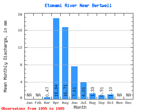
| Units: | m3/s |
| Statistic | Jan | Feb | Mar | Apr | May | Jun | Jul | Aug | Sep | Oct | Nov | Dec | Annual |
|---|---|---|---|---|---|---|---|---|---|---|---|---|---|
| Mean | 0.43 | 17.00 | 15.07 | 6.87 | 3.62 | 1.20 | 0.82 | 0.99 | |||||
| Standard Deviation | 0.55 | 13.12 | 15.89 | 10.03 | 5.36 | 2.80 | 1.44 | 1.14 | |||||
| Min | 0.00 | 0.83 | 0.49 | 0.22 | 0.00 | 0.00 | 0.00 | 0.00 | |||||
| Max | 2.53 | 44.13 | 64.14 | 50.83 | 26.13 | 13.72 | 7.79 | 5.62 | |||||
| Coefficient of Variation | 1.29 | 0.77 | 1.05 | 1.46 | 1.48 | 2.34 | 1.76 | 1.15 |
 Return to R-Arctic Net Home Page