|
|
|||||||||||||||||
| Point ID: 5454 | Downloads | Plots | Site Data | Other Close Sites | Code: 05KH008 |
|
|
|||||||||||||||||
| Download | |
|---|---|
| Site Descriptor Information | Site Time Series Data |
| Link to all available data | |
| View: | Time Series | All |
| Units: | m3/s |
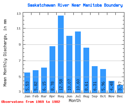
| Statistic | Jan | Feb | Mar | Apr | May | Jun | Jul | Aug | Sep | Oct | Nov | Dec | Annual |
|---|---|---|---|---|---|---|---|---|---|---|---|---|---|
| Mean | 3.47 | 3.69 | 3.86 | 5.51 | 7.90 | 6.33 | 6.65 | 5.41 | 3.96 | 3.74 | 2.81 | 2.49 | 55.05 |
| Standard Deviation | 0.52 | 0.52 | 0.73 | 1.18 | 3.97 | 2.45 | 2.57 | 2.10 | 1.05 | 0.87 | 0.59 | 0.50 | 14.44 |
| Min | 2.29 | 2.78 | 2.88 | 3.94 | 3.52 | 2.63 | 3.13 | 2.96 | 2.66 | 2.51 | 1.88 | 1.85 | 39.54 |
| Max | 4.03 | 4.72 | 5.01 | 7.48 | 18.21 | 13.04 | 10.45 | 8.74 | 6.19 | 5.43 | 4.09 | 3.54 | 87.92 |
| Coefficient of Variation | 0.15 | 0.14 | 0.19 | 0.21 | 0.50 | 0.39 | 0.39 | 0.39 | 0.26 | 0.23 | 0.21 | 0.20 | 0.26 |
| Other Close Sites | ||||||
|---|---|---|---|---|---|---|
| PointID | Latitude | Longitude | Drainage Area | Source | Name | |
| 5456 | "SASKATCHEWAN RIVER BELOW CUMBERLAND HOUSE" | 53.88 | 816597 | Hydat | ||
 Return to R-Arctic Net Home Page