|
|
|||||||||||||||||
| Point ID: 5452 | Downloads | Plots | Site Data | Code: 05KG007 |
|
|
|||||||||||||||||
| Download | |
|---|---|
| Site Descriptor Information | Site Time Series Data |
| Link to all available data | |
| View: | Time Series | All |
| Units: | m3/s |
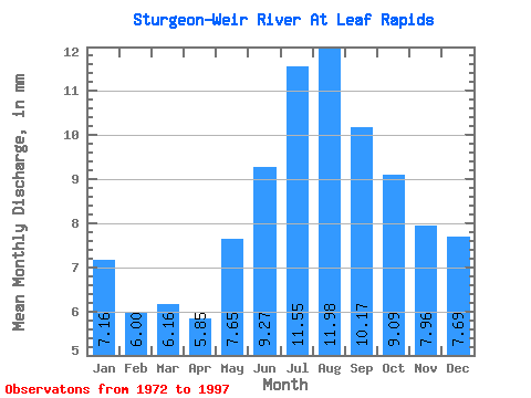
| Statistic | Jan | Feb | Mar | Apr | May | Jun | Jul | Aug | Sep | Oct | Nov | Dec | Annual |
|---|---|---|---|---|---|---|---|---|---|---|---|---|---|
| Mean | 7.16 | 6.05 | 6.16 | 5.85 | 7.65 | 9.27 | 11.55 | 11.98 | 10.17 | 9.09 | 7.96 | 7.69 | 99.73 |
| Standard Deviation | 3.24 | 2.46 | 2.15 | 1.95 | 3.16 | 5.05 | 7.76 | 9.37 | 7.49 | 5.95 | 4.51 | 3.92 | 51.30 |
| Min | 3.02 | 2.69 | 2.93 | 2.96 | 3.68 | 3.60 | 3.91 | 3.42 | 3.15 | 2.93 | 2.82 | 2.98 | 40.20 |
| Max | 15.60 | 12.06 | 10.65 | 10.29 | 16.54 | 23.86 | 31.24 | 46.12 | 37.85 | 29.33 | 21.81 | 18.51 | 247.89 |
| Coefficient of Variation | 0.45 | 0.41 | 0.35 | 0.33 | 0.41 | 0.55 | 0.67 | 0.78 | 0.74 | 0.66 | 0.57 | 0.51 | 0.51 |
 Return to R-Arctic Net Home Page