|
|
|||||||||||||||||
| Point ID: 542 | Downloads | Plots | Site Data | Code: 05FB002 |
|
|
|||||||||||||||||
| Download | |
|---|---|
| Site Descriptor Information | Site Time Series Data |
| Link to all available data | |
| View: | Time Series | All |
| Units: | m3/s |
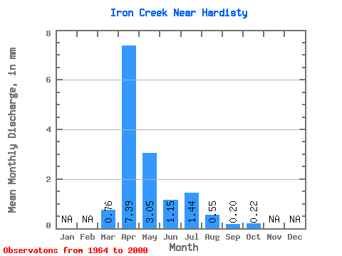
| Statistic | Jan | Feb | Mar | Apr | May | Jun | Jul | Aug | Sep | Oct | Nov | Dec | Annual |
|---|---|---|---|---|---|---|---|---|---|---|---|---|---|
| Mean | 0.21 | 2.06 | 0.85 | 0.32 | 0.40 | 0.15 | 0.06 | 0.06 | |||||
| Standard Deviation | 0.42 | 2.96 | 1.64 | 0.37 | 0.79 | 0.42 | 0.09 | 0.11 | |||||
| Min | 0.00 | 0.18 | 0.01 | 0.00 | 0.00 | 0.00 | 0.00 | 0.00 | |||||
| Max | 1.82 | 17.03 | 9.87 | 1.70 | 4.27 | 2.50 | 0.41 | 0.48 | |||||
| Coefficient of Variation | 2.00 | 1.44 | 1.93 | 1.16 | 1.96 | 2.73 | 1.67 | 1.76 |
 Return to R-Arctic Net Home Page