|
|
|||||||||||||||||
| Point ID: 5414 | Downloads | Plots | Site Data | Code: 05JM012 |
|
|
|||||||||||||||||
| Download | |
|---|---|
| Site Descriptor Information | Site Time Series Data |
| Link to all available data | |
| View: | Time Series | All |
| Units: | m3/s |
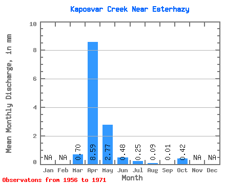
| Statistic | Jan | Feb | Mar | Apr | May | Jun | Jul | Aug | Sep | Oct | Nov | Dec | Annual |
|---|---|---|---|---|---|---|---|---|---|---|---|---|---|
| Mean | 0.12 | 1.46 | 0.47 | 0.08 | 0.04 | 0.01 | 0.00 | 0.07 | |||||
| Standard Deviation | 0.25 | 2.37 | 1.33 | 0.27 | 0.13 | 0.06 | 0.00 | 0.23 | |||||
| Min | 0.00 | 0.00 | 0.00 | 0.00 | 0.00 | 0.00 | 0.00 | 0.00 | |||||
| Max | 0.97 | 9.54 | 5.42 | 1.09 | 0.54 | 0.22 | 0.01 | 0.91 | |||||
| Coefficient of Variation | 2.10 | 1.63 | 2.84 | 3.36 | 3.14 | 3.62 | 2.29 | 3.17 |
 Return to R-Arctic Net Home Page