|
|
|||||||||||||||||
| Point ID: 5384 | Downloads | Plots | Site Data | Code: 05JG013 |
|
|
|||||||||||||||||
| Download | |
|---|---|
| Site Descriptor Information | Site Time Series Data |
| Link to all available data | |
| View: | Time Series | All |
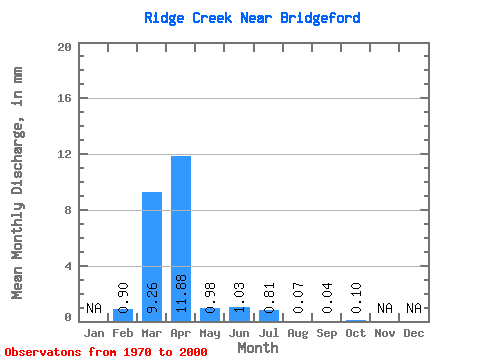
| Units: | m3/s |
| Statistic | Jan | Feb | Mar | Apr | May | Jun | Jul | Aug | Sep | Oct | Nov | Dec | Annual |
|---|---|---|---|---|---|---|---|---|---|---|---|---|---|
| Mean | 0.37 | 3.79 | 4.85 | 0.40 | 0.42 | 0.33 | 0.03 | 0.02 | 0.04 | ||||
| Standard Deviation | 0.58 | 5.49 | 8.50 | 0.75 | 1.24 | 0.73 | 0.06 | 0.03 | 0.05 | ||||
| Min | 0.00 | 0.00 | 0.04 | 0.03 | 0.00 | 0.00 | 0.00 | 0.00 | 0.00 | ||||
| Max | 1.64 | 19.50 | 35.61 | 4.13 | 6.48 | 3.07 | 0.27 | 0.18 | 0.25 | ||||
| Coefficient of Variation | 1.56 | 1.45 | 1.75 | 1.86 | 2.95 | 2.20 | 2.08 | 1.84 | 1.18 |
 Return to R-Arctic Net Home Page