|
|
|||||||||||||||||
| Point ID: 5353 | Downloads | Plots | Site Data | Code: 05JC007 |
|
|
|||||||||||||||||
| Download | |
|---|---|
| Site Descriptor Information | Site Time Series Data |
| Link to all available data | |
| View: | Time Series | All |
| Units: | m3/s |
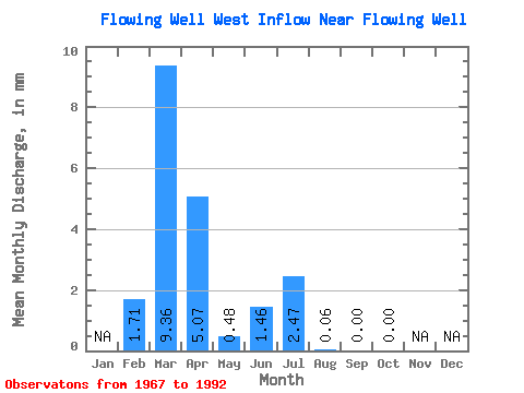
| Statistic | Jan | Feb | Mar | Apr | May | Jun | Jul | Aug | Sep | Oct | Nov | Dec | Annual |
|---|---|---|---|---|---|---|---|---|---|---|---|---|---|
| Mean | 1.68 | 9.05 | 4.91 | 0.47 | 1.41 | 2.39 | 0.05 | 0.00 | 0.01 | ||||
| Standard Deviation | 3.80 | 11.87 | 7.56 | 0.78 | 4.40 | 6.59 | 0.12 | 0.01 | 0.03 | ||||
| Min | 0.00 | 0.00 | 0.00 | 0.00 | 0.00 | 0.00 | 0.00 | 0.00 | 0.00 | ||||
| Max | 10.25 | 39.34 | 24.51 | 2.65 | 18.39 | 24.91 | 0.44 | 0.03 | 0.15 | ||||
| Coefficient of Variation | 2.27 | 1.31 | 1.54 | 1.65 | 3.13 | 2.76 | 2.58 | 4.24 | 4.24 |
 Return to R-Arctic Net Home Page