|
|
|||||||||||||||||
| Point ID: 5348 | Downloads | Plots | Site Data | Code: 05JB007 |
|
|
|||||||||||||||||
| Download | |
|---|---|
| Site Descriptor Information | Site Time Series Data |
| Link to all available data | |
| View: | Time Series | All |
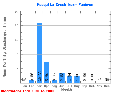
| Units: | m3/s |
| Statistic | Jan | Feb | Mar | Apr | May | Jun | Jul | Aug | Sep | Oct | Nov | Dec | Annual |
|---|---|---|---|---|---|---|---|---|---|---|---|---|---|
| Mean | 0.60 | 11.55 | 4.10 | 0.54 | 1.98 | 1.36 | 1.32 | 0.03 | 0.01 | ||||
| Standard Deviation | 0.99 | 15.05 | 6.75 | 0.61 | 6.41 | 4.57 | 6.30 | 0.16 | 0.04 | ||||
| Min | 0.00 | 0.00 | 0.00 | 0.00 | 0.00 | 0.00 | 0.00 | 0.00 | 0.00 | ||||
| Max | 2.87 | 61.91 | 24.05 | 1.93 | 30.90 | 21.00 | 30.21 | 0.75 | 0.17 | ||||
| Coefficient of Variation | 1.64 | 1.30 | 1.65 | 1.14 | 3.24 | 3.37 | 4.79 | 4.80 | 4.80 |
 Return to R-Arctic Net Home Page