|
|
|||||||||||||||||
| Point ID: 5344 | Downloads | Plots | Site Data | Code: 05JB002 |
|
|
|||||||||||||||||
| Download | |
|---|---|
| Site Descriptor Information | Site Time Series Data |
| Link to all available data | |
| View: | Time Series | All |
| Units: | m3/s |
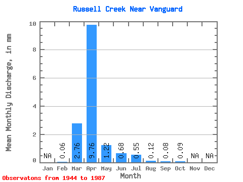
| Statistic | Jan | Feb | Mar | Apr | May | Jun | Jul | Aug | Sep | Oct | Nov | Dec | Annual |
|---|---|---|---|---|---|---|---|---|---|---|---|---|---|
| Mean | 0.06 | 2.55 | 9.01 | 1.13 | 0.63 | 0.51 | 0.11 | 0.07 | 0.08 | ||||
| Standard Deviation | 0.08 | 4.42 | 10.99 | 1.45 | 0.78 | 1.63 | 0.22 | 0.12 | 0.12 | ||||
| Min | 0.00 | 0.00 | 0.00 | 0.00 | 0.00 | 0.00 | 0.00 | 0.00 | 0.00 | ||||
| Max | 0.15 | 17.88 | 53.25 | 7.50 | 4.12 | 8.81 | 0.74 | 0.53 | 0.60 | ||||
| Coefficient of Variation | 1.49 | 1.73 | 1.22 | 1.28 | 1.24 | 3.21 | 1.97 | 1.67 | 1.51 |
 Return to R-Arctic Net Home Page