|
|
|||||||||||||||||
| Point ID: 5318 | Downloads | Plots | Site Data | Code: 05HF019 |
|
|
|||||||||||||||||
| Download | |
|---|---|
| Site Descriptor Information | Site Time Series Data |
| Link to all available data | |
| View: | Time Series | All |
| Units: | m3/s |
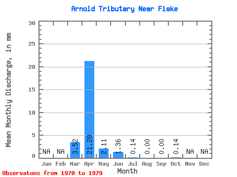
| Statistic | Jan | Feb | Mar | Apr | May | Jun | Jul | Aug | Sep | Oct | Nov | Dec | Annual |
|---|---|---|---|---|---|---|---|---|---|---|---|---|---|
| Mean | 2.71 | 16.64 | 1.62 | 1.10 | 0.15 | 0.01 | 0.01 | 0.06 | |||||
| Standard Deviation | 3.15 | 18.78 | 2.13 | 1.82 | 0.19 | 0.04 | 0.03 | 0.08 | |||||
| Min | 0.00 | 0.53 | 0.11 | 0.00 | 0.00 | 0.00 | 0.00 | 0.00 | |||||
| Max | 8.49 | 54.85 | 7.28 | 5.23 | 0.55 | 0.11 | 0.11 | 0.22 | |||||
| Coefficient of Variation | 1.16 | 1.13 | 1.31 | 1.65 | 1.22 | 3.16 | 3.16 | 1.41 |
 Return to R-Arctic Net Home Page