|
|
|||||||||||||||||
| Point ID: 5309 | Downloads | Plots | Site Data | Code: 05HF005 |
|
|
|||||||||||||||||
| Download | |
|---|---|
| Site Descriptor Information | Site Time Series Data |
| Link to all available data | |
| View: | Time Series | All |
| Units: | m3/s |
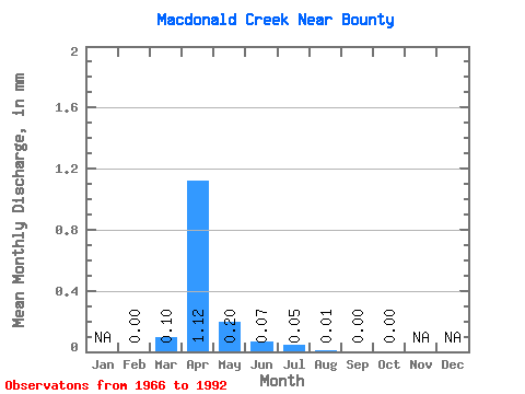
| Statistic | Jan | Feb | Mar | Apr | May | Jun | Jul | Aug | Sep | Oct | Nov | Dec | Annual |
|---|---|---|---|---|---|---|---|---|---|---|---|---|---|
| Mean | 0.00 | 0.10 | 1.12 | 0.20 | 0.07 | 0.05 | 0.01 | 0.00 | 0.00 | ||||
| Standard Deviation | 0.00 | 0.15 | 2.01 | 0.36 | 0.11 | 0.11 | 0.03 | 0.01 | 0.01 | ||||
| Min | 0.00 | 0.00 | 0.00 | 0.00 | 0.00 | 0.00 | 0.00 | 0.00 | 0.00 | ||||
| Max | 0.00 | 0.57 | 9.03 | 1.35 | 0.37 | 0.34 | 0.16 | 0.03 | 0.03 | ||||
| Coefficient of Variation | 1.53 | 1.80 | 1.77 | 1.58 | 1.99 | 2.76 | 2.79 | 2.32 |
 Return to R-Arctic Net Home Page