|
|
|||||||||||||||||
| Point ID: 5285 | Downloads | Plots | Site Data | Code: 05HD002 |
|
|
|||||||||||||||||
| Download | |
|---|---|
| Site Descriptor Information | Site Time Series Data |
| Link to all available data | |
| View: | Time Series | All |
| Units: | m3/s |
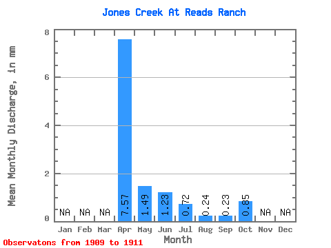
| Statistic | Jan | Feb | Mar | Apr | May | Jun | Jul | Aug | Sep | Oct | Nov | Dec | Annual |
|---|---|---|---|---|---|---|---|---|---|---|---|---|---|
| Mean | 5.62 | 1.11 | 0.92 | 0.52 | 0.18 | 0.17 | 0.63 | ||||||
| Standard Deviation | 4.66 | 0.74 | 1.04 | 0.27 | 0.17 | 0.53 | |||||||
| Min | 2.33 | 0.59 | 0.19 | 0.34 | 0.06 | 0.17 | 0.26 | ||||||
| Max | 8.92 | 1.63 | 1.66 | 0.71 | 0.29 | 0.17 | 1.00 | ||||||
| Coefficient of Variation | 0.83 | 0.66 | 1.12 | 0.51 | 0.94 | 0.84 |
 Return to R-Arctic Net Home Page