|
|
|||||||||||||||||
| Point ID: 5269 | Downloads | Plots | Site Data | Code: 05HA062 |
|
|
|||||||||||||||||
| Download | |
|---|---|
| Site Descriptor Information | Site Time Series Data |
| Link to all available data | |
| View: | Time Series | All |
| Units: | m3/s |
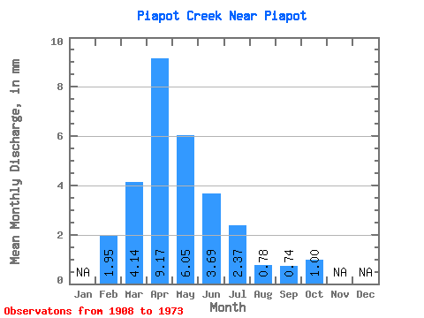
| Statistic | Jan | Feb | Mar | Apr | May | Jun | Jul | Aug | Sep | Oct | Nov | Dec | Annual |
|---|---|---|---|---|---|---|---|---|---|---|---|---|---|
| Mean | 1.96 | 4.13 | 9.17 | 6.05 | 3.68 | 2.37 | 0.79 | 0.75 | 1.00 | ||||
| Standard Deviation | 4.88 | 9.89 | 6.25 | 5.96 | 3.91 | 1.25 | 0.81 | 0.84 | |||||
| Min | 1.96 | 0.07 | 0.25 | 0.02 | 0.21 | 0.02 | 0.00 | 0.00 | 0.00 | ||||
| Max | 1.96 | 14.54 | 36.46 | 21.71 | 23.39 | 14.70 | 5.51 | 3.22 | 3.46 | ||||
| Coefficient of Variation | 1.18 | 1.08 | 1.03 | 1.62 | 1.65 | 1.59 | 1.09 | 0.85 |
 Return to R-Arctic Net Home Page