|
|
|||||||||||||||||
| Point ID: 5232 | Downloads | Plots | Site Data | Code: 05HA007 |
|
|
|||||||||||||||||
| Download | |
|---|---|
| Site Descriptor Information | Site Time Series Data |
| Link to all available data | |
| View: | Time Series | All |
| Units: | m3/s |
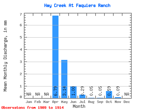
| Statistic | Jan | Feb | Mar | Apr | May | Jun | Jul | Aug | Sep | Oct | Nov | Dec | Annual |
|---|---|---|---|---|---|---|---|---|---|---|---|---|---|
| Mean | 6.77 | 3.16 | 1.00 | 0.29 | 0.04 | 0.04 | 0.61 | 0.10 | |||||
| Standard Deviation | 6.92 | 4.41 | 1.59 | 0.52 | 0.06 | 0.09 | 1.07 | ||||||
| Min | 0.00 | 0.00 | 0.00 | 0.00 | 0.00 | 0.00 | 0.00 | 0.10 | |||||
| Max | 16.19 | 9.91 | 3.85 | 1.32 | 0.15 | 0.19 | 2.50 | 0.10 | |||||
| Coefficient of Variation | 1.02 | 1.40 | 1.59 | 1.81 | 1.63 | 2.24 | 1.76 |
 Return to R-Arctic Net Home Page