|
|
|||||||||||||||||
| Point ID: 5228 | Downloads | Plots | Site Data | Code: 05HA002 |
|
|
|||||||||||||||||
| Download | |
|---|---|
| Site Descriptor Information | Site Time Series Data |
| Link to all available data | |
| View: | Time Series | All |
| Units: | m3/s |
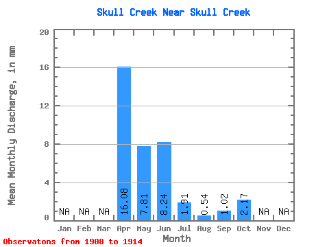
| Statistic | Jan | Feb | Mar | Apr | May | Jun | Jul | Aug | Sep | Oct | Nov | Dec | Annual |
|---|---|---|---|---|---|---|---|---|---|---|---|---|---|
| Mean | 14.80 | 7.18 | 7.59 | 1.75 | 0.49 | 0.94 | 1.99 | ||||||
| Standard Deviation | 10.30 | 11.12 | 15.35 | 3.17 | 0.58 | 0.55 | 0.96 | ||||||
| Min | 3.13 | 1.47 | 0.84 | 0.05 | 0.00 | 0.10 | 1.13 | ||||||
| Max | 29.48 | 29.67 | 38.88 | 8.85 | 1.60 | 1.65 | 3.68 | ||||||
| Coefficient of Variation | 0.70 | 1.55 | 2.02 | 1.81 | 1.18 | 0.58 | 0.48 |
 Return to R-Arctic Net Home Page