|
|
|||||||||||||||||
| Point ID: 5194 | Downloads | Plots | Site Data | Code: 05EF005 |
|
|
|||||||||||||||||
| Download | |
|---|---|
| Site Descriptor Information | Site Time Series Data |
| Link to all available data | |
| View: | Time Series | All |
| Units: | m3/s |
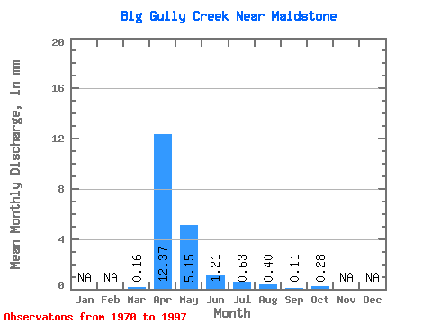
| Statistic | Jan | Feb | Mar | Apr | May | Jun | Jul | Aug | Sep | Oct | Nov | Dec | Annual |
|---|---|---|---|---|---|---|---|---|---|---|---|---|---|
| Mean | 0.05 | 4.32 | 1.79 | 0.42 | 0.22 | 0.14 | 0.04 | 0.10 | |||||
| Standard Deviation | 0.10 | 6.69 | 3.04 | 0.75 | 0.41 | 0.41 | 0.09 | 0.26 | |||||
| Min | 0.00 | 0.00 | 0.00 | 0.00 | 0.00 | 0.00 | 0.00 | 0.00 | |||||
| Max | 0.33 | 31.04 | 14.33 | 3.12 | 1.67 | 2.00 | 0.43 | 1.04 | |||||
| Coefficient of Variation | 1.79 | 1.55 | 1.69 | 1.77 | 1.88 | 2.91 | 2.46 | 2.69 |
 Return to R-Arctic Net Home Page