|
|
|||||||||||||||||
| Point ID: 5187 | Downloads | Plots | Site Data | Code: 04NA002 |
|
|
|||||||||||||||||
| Download | |
|---|---|
| Site Descriptor Information | Site Time Series Data |
| Link to all available data | |
| View: | Time Series | All |
| Units: | m3/s |
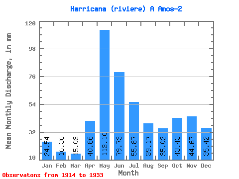
| Statistic | Jan | Feb | Mar | Apr | May | Jun | Jul | Aug | Sep | Oct | Nov | Dec | Annual |
|---|---|---|---|---|---|---|---|---|---|---|---|---|---|
| Mean | 24.53 | 16.50 | 15.03 | 40.86 | 113.09 | 79.73 | 55.86 | 39.16 | 35.02 | 43.43 | 44.67 | 35.41 | 543.46 |
| Standard Deviation | 8.07 | 6.58 | 5.92 | 22.47 | 31.46 | 26.00 | 23.82 | 17.90 | 15.25 | 26.37 | 22.83 | 12.44 | 140.32 |
| Min | 11.21 | 7.09 | 6.54 | 10.56 | 62.29 | 44.87 | 25.18 | 16.59 | 13.73 | 6.84 | 9.16 | 12.23 | 339.90 |
| Max | 37.55 | 32.09 | 33.62 | 88.04 | 187.75 | 134.53 | 98.24 | 68.55 | 75.36 | 112.80 | 106.36 | 56.54 | 933.08 |
| Coefficient of Variation | 0.33 | 0.40 | 0.39 | 0.55 | 0.28 | 0.33 | 0.43 | 0.46 | 0.43 | 0.61 | 0.51 | 0.35 | 0.26 |
 Return to R-Arctic Net Home Page