|
|
|||||||||||||||||
| Point ID: 5184 | Downloads | Plots | Site Data | Code: 03MD002 |
|
|
|||||||||||||||||
| Download | |
|---|---|
| Site Descriptor Information | Site Time Series Data |
| Link to all available data | |
| View: | Time Series | All |
| Units: | m3/s |
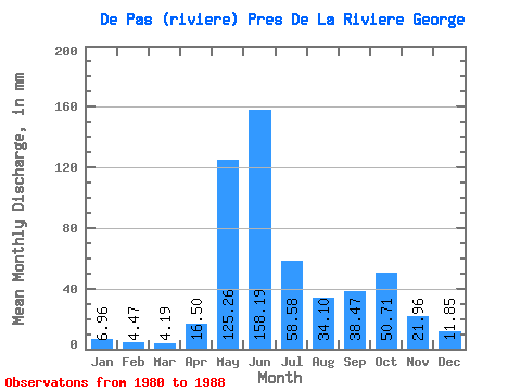
| Statistic | Jan | Feb | Mar | Apr | May | Jun | Jul | Aug | Sep | Oct | Nov | Dec | Annual |
|---|---|---|---|---|---|---|---|---|---|---|---|---|---|
| Mean | 6.96 | 4.51 | 4.19 | 16.50 | 125.24 | 158.19 | 58.57 | 34.10 | 38.47 | 50.70 | 21.96 | 11.85 | 496.18 |
| Standard Deviation | 2.50 | 1.60 | 1.56 | 21.64 | 46.20 | 94.23 | 14.28 | 12.74 | 13.80 | 26.93 | 12.68 | 4.89 | 85.00 |
| Min | 4.43 | 2.71 | 2.22 | 2.30 | 66.62 | 61.90 | 33.49 | 23.00 | 22.01 | 24.03 | 11.39 | 6.13 | 390.33 |
| Max | 12.04 | 7.89 | 7.06 | 61.47 | 178.98 | 309.49 | 68.84 | 55.96 | 57.60 | 95.93 | 49.00 | 19.19 | 575.60 |
| Coefficient of Variation | 0.36 | 0.35 | 0.37 | 1.31 | 0.37 | 0.60 | 0.24 | 0.37 | 0.36 | 0.53 | 0.58 | 0.41 | 0.17 |
 Return to R-Arctic Net Home Page