|
|
|||||||||||||||||
| Point ID: 5182 | Downloads | Plots | Site Data | Code: 03MC001 |
|
|
|||||||||||||||||
| Download | |
|---|---|
| Site Descriptor Information | Site Time Series Data |
| Link to all available data | |
| View: | Time Series | All |
| Units: | m3/s |
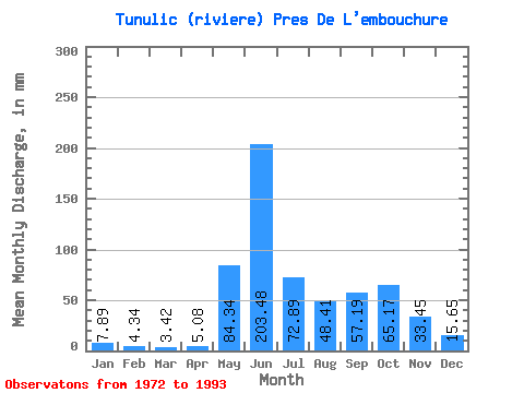
| Statistic | Jan | Feb | Mar | Apr | May | Jun | Jul | Aug | Sep | Oct | Nov | Dec | Annual |
|---|---|---|---|---|---|---|---|---|---|---|---|---|---|
| Mean | 7.89 | 4.38 | 3.42 | 5.08 | 84.33 | 203.48 | 72.88 | 48.40 | 57.19 | 65.16 | 33.45 | 15.65 | 601.13 |
| Standard Deviation | 2.71 | 1.94 | 1.90 | 10.74 | 77.39 | 77.29 | 24.83 | 24.94 | 27.30 | 24.15 | 12.12 | 4.96 | 87.20 |
| Min | 4.53 | 2.29 | 1.61 | 1.32 | 1.70 | 59.24 | 42.79 | 23.36 | 23.17 | 27.22 | 17.12 | 8.88 | 336.92 |
| Max | 13.83 | 8.95 | 8.22 | 51.35 | 283.08 | 290.90 | 125.89 | 123.71 | 113.40 | 109.16 | 68.04 | 27.29 | 768.23 |
| Coefficient of Variation | 0.34 | 0.44 | 0.56 | 2.12 | 0.92 | 0.38 | 0.34 | 0.52 | 0.48 | 0.37 | 0.36 | 0.32 | 0.14 |
 Return to R-Arctic Net Home Page