|
|
|||||||||||||||||
| Point ID: 5181 | Downloads | Plots | Site Data | Code: 03MB002 |
|
|
|||||||||||||||||
| Download | |
|---|---|
| Site Descriptor Information | Site Time Series Data |
| Link to all available data | |
| View: | Time Series | All |
| Units: | m3/s |
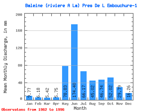
| Statistic | Jan | Feb | Mar | Apr | May | Jun | Jul | Aug | Sep | Oct | Nov | Dec | Annual |
|---|---|---|---|---|---|---|---|---|---|---|---|---|---|
| Mean | 9.77 | 6.23 | 5.42 | 5.75 | 78.81 | 174.40 | 66.16 | 45.02 | 46.74 | 52.01 | 29.79 | 16.25 | 537.72 |
| Standard Deviation | 2.63 | 1.87 | 1.80 | 5.03 | 59.66 | 64.41 | 21.69 | 20.29 | 19.82 | 17.57 | 11.24 | 5.18 | 78.77 |
| Min | 4.94 | 3.39 | 1.88 | 1.32 | 3.66 | 51.23 | 25.34 | 18.78 | 16.96 | 24.89 | 13.74 | 8.41 | 356.65 |
| Max | 16.80 | 10.23 | 9.35 | 32.53 | 269.60 | 315.74 | 101.55 | 99.75 | 115.68 | 102.45 | 55.49 | 30.02 | 691.63 |
| Coefficient of Variation | 0.27 | 0.30 | 0.33 | 0.88 | 0.76 | 0.37 | 0.33 | 0.45 | 0.42 | 0.34 | 0.38 | 0.32 | 0.15 |
 Return to R-Arctic Net Home Page