|
|
|||||||||||||||||
| Point ID: 5179 | Downloads | Plots | Site Data | Code: 03LF002 |
|
|
|||||||||||||||||
| Download | |
|---|---|
| Site Descriptor Information | Site Time Series Data |
| Link to all available data | |
| View: | Time Series | All |
| Units: | m3/s |
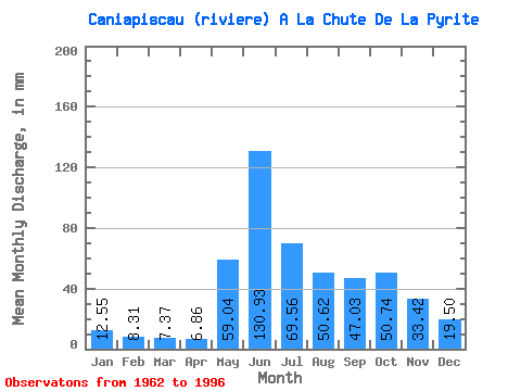
| Statistic | Jan | Feb | Mar | Apr | May | Jun | Jul | Aug | Sep | Oct | Nov | Dec | Annual |
|---|---|---|---|---|---|---|---|---|---|---|---|---|---|
| Mean | 12.55 | 8.38 | 7.37 | 6.86 | 59.03 | 130.93 | 69.55 | 50.61 | 47.03 | 50.73 | 33.42 | 19.50 | 498.97 |
| Standard Deviation | 6.04 | 4.05 | 3.61 | 3.38 | 37.79 | 59.88 | 31.66 | 29.00 | 19.18 | 16.37 | 15.27 | 9.39 | 168.23 |
| Min | 5.58 | 3.46 | 2.94 | 2.25 | 9.06 | 31.59 | 20.32 | 12.93 | 14.11 | 20.76 | 12.73 | 7.99 | 226.69 |
| Max | 22.98 | 16.32 | 15.09 | 15.61 | 185.72 | 249.08 | 151.81 | 135.33 | 102.45 | 83.35 | 61.04 | 41.83 | 797.15 |
| Coefficient of Variation | 0.48 | 0.48 | 0.49 | 0.49 | 0.64 | 0.46 | 0.46 | 0.57 | 0.41 | 0.32 | 0.46 | 0.48 | 0.34 |
 Return to R-Arctic Net Home Page