|
|
|||||||||||||||||
| Point ID: 5177 | Downloads | Plots | Site Data | Code: 03LD006 |
|
|
|||||||||||||||||
| Download | |
|---|---|
| Site Descriptor Information | Site Time Series Data |
| Link to all available data | |
| View: | Time Series | All |
| Units: | m3/s |
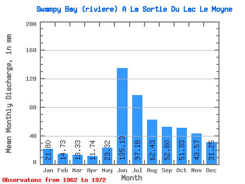
| Statistic | Jan | Feb | Mar | Apr | May | Jun | Jul | Aug | Sep | Oct | Nov | Dec | Annual |
|---|---|---|---|---|---|---|---|---|---|---|---|---|---|
| Mean | 21.80 | 14.86 | 13.32 | 11.74 | 23.31 | 135.13 | 97.17 | 62.42 | 52.80 | 51.32 | 43.58 | 31.24 | 579.06 |
| Standard Deviation | 3.65 | 1.71 | 1.49 | 1.50 | 10.45 | 34.43 | 30.24 | 17.24 | 14.64 | 10.39 | 12.44 | 7.24 | 62.71 |
| Min | 15.19 | 11.83 | 11.18 | 9.42 | 9.40 | 66.19 | 46.82 | 29.98 | 26.90 | 37.05 | 28.04 | 19.87 | 447.69 |
| Max | 27.12 | 17.34 | 15.12 | 13.99 | 44.97 | 185.84 | 142.32 | 83.03 | 80.37 | 61.31 | 61.78 | 42.27 | 654.56 |
| Coefficient of Variation | 0.17 | 0.12 | 0.11 | 0.13 | 0.45 | 0.26 | 0.31 | 0.28 | 0.28 | 0.20 | 0.28 | 0.23 | 0.11 |
 Return to R-Arctic Net Home Page