|
|
|||||||||||||||||
| Point ID: 5174 | Downloads | Plots | Site Data | Other Close Sites | Code: 03LA001 |
|
|
|||||||||||||||||
| Download | |
|---|---|
| Site Descriptor Information | Site Time Series Data |
| Link to all available data | |
| View: | Time Series | All |
| Units: | m3/s |
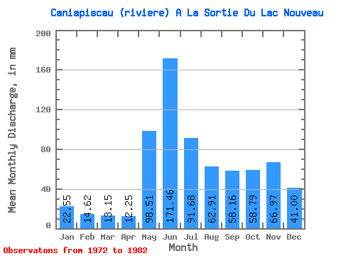
| Statistic | Jan | Feb | Mar | Apr | May | Jun | Jul | Aug | Sep | Oct | Nov | Dec | Annual |
|---|---|---|---|---|---|---|---|---|---|---|---|---|---|
| Mean | 22.54 | 14.74 | 13.15 | 12.25 | 98.50 | 171.46 | 91.66 | 62.90 | 58.16 | 58.78 | 66.97 | 41.00 | 721.69 |
| Standard Deviation | 8.99 | 4.83 | 4.03 | 4.27 | 65.58 | 26.54 | 22.64 | 18.76 | 21.16 | 14.18 | 48.60 | 24.87 | 193.62 |
| Min | 14.98 | 9.84 | 8.61 | 7.89 | 25.19 | 121.91 | 64.91 | 39.60 | 36.68 | 40.17 | 36.24 | 21.22 | 535.91 |
| Max | 39.60 | 21.61 | 20.99 | 19.99 | 251.91 | 217.46 | 129.36 | 104.17 | 100.28 | 81.13 | 197.69 | 99.29 | 1130.90 |
| Coefficient of Variation | 0.40 | 0.33 | 0.31 | 0.35 | 0.67 | 0.15 | 0.25 | 0.30 | 0.36 | 0.24 | 0.73 | 0.61 | 0.27 |
| Other Close Sites | ||||||
|---|---|---|---|---|---|---|
| PointID | Latitude | Longitude | Drainage Area | Source | Name | |
| 5175 | "CANIAPISCAU (RIVIERE) EN AMONT DE LA DECHARGE DU LAC CHASTRIER" | 53.99 | -1406366 | Hydat | ||
 Return to R-Arctic Net Home Page