|
|
|||||||||||||||||
| Point ID: 5169 | Downloads | Plots | Site Data | Code: 03JB004 |
|
|
|||||||||||||||||
| Download | |
|---|---|
| Site Descriptor Information | Site Time Series Data |
| Link to all available data | |
| View: | Time Series | All |
| Units: | m3/s |
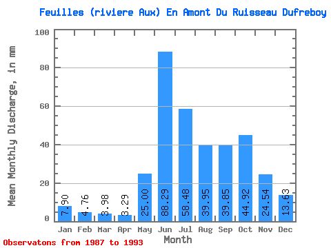
| Statistic | Jan | Feb | Mar | Apr | May | Jun | Jul | Aug | Sep | Oct | Nov | Dec | Annual |
|---|---|---|---|---|---|---|---|---|---|---|---|---|---|
| Mean | 7.90 | 4.80 | 3.98 | 3.29 | 25.00 | 88.29 | 58.47 | 39.94 | 39.85 | 44.91 | 24.54 | 13.63 | 349.15 |
| Standard Deviation | 1.66 | 1.14 | 0.91 | 0.61 | 19.84 | 17.98 | 22.74 | 11.64 | 8.57 | 5.01 | 3.36 | 2.23 | 43.26 |
| Min | 5.84 | 3.37 | 2.80 | 2.45 | 3.48 | 64.46 | 37.84 | 24.57 | 27.22 | 38.79 | 20.95 | 10.90 | 281.37 |
| Max | 10.66 | 6.84 | 5.57 | 4.17 | 44.48 | 109.34 | 96.38 | 52.22 | 50.92 | 53.16 | 29.59 | 16.51 | 390.47 |
| Coefficient of Variation | 0.21 | 0.24 | 0.23 | 0.19 | 0.79 | 0.20 | 0.39 | 0.29 | 0.21 | 0.11 | 0.14 | 0.16 | 0.12 |
 Return to R-Arctic Net Home Page