|
|
|||||||||||||||||
| Point ID: 5166 | Downloads | Plots | Site Data | Other Close Sites | Code: 03HB005 |
|
|
|||||||||||||||||
| Download | |
|---|---|
| Site Descriptor Information | Site Time Series Data |
| Link to all available data | |
| View: | Time Series | All |
| Units: | m3/s |
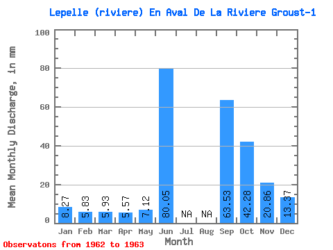
| Statistic | Jan | Feb | Mar | Apr | May | Jun | Jul | Aug | Sep | Oct | Nov | Dec | Annual |
|---|---|---|---|---|---|---|---|---|---|---|---|---|---|
| Mean | 8.27 | 5.88 | 5.93 | 5.56 | 7.12 | 80.05 | 63.53 | 42.27 | 20.86 | 13.36 | |||
| Standard Deviation | |||||||||||||
| Min | 8.27 | 5.88 | 5.93 | 5.56 | 7.12 | 80.05 | 63.53 | 42.27 | 20.86 | 13.36 | |||
| Max | 8.27 | 5.88 | 5.93 | 5.56 | 7.12 | 80.05 | 63.53 | 42.27 | 20.86 | 13.36 | |||
| Coefficient of Variation |
| Other Close Sites | ||||||
|---|---|---|---|---|---|---|
| PointID | Latitude | Longitude | Drainage Area | Source | Name | |
| 5165 | "LEPELLE (RIVIERE) EN AVAL DE LA RIVIERE GROUST-2" | 60.19 | -976854 | Hydat | ||
 Return to R-Arctic Net Home Page