|
|
|||||||||||||||||
| Point ID: 5152 | Downloads | Plots | Site Data | Code: 03FC005 |
|
|
|||||||||||||||||
| Download | |
|---|---|
| Site Descriptor Information | Site Time Series Data |
| Link to all available data | |
| View: | Time Series | All |
| Units: | m3/s |
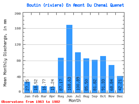
| Statistic | Jan | Feb | Mar | Apr | May | Jun | Jul | Aug | Sep | Oct | Nov | Dec | Annual |
|---|---|---|---|---|---|---|---|---|---|---|---|---|---|
| Mean | 27.34 | 18.68 | 16.77 | 15.24 | 87.16 | 168.63 | 100.88 | 85.48 | 81.82 | 91.31 | 68.84 | 42.20 | 799.99 |
| Standard Deviation | 5.02 | 2.94 | 2.97 | 3.06 | 36.55 | 65.09 | 34.17 | 42.86 | 29.00 | 33.79 | 20.38 | 8.80 | 134.28 |
| Min | 18.33 | 12.06 | 11.52 | 9.88 | 37.32 | 62.25 | 44.34 | 45.00 | 33.99 | 49.61 | 39.52 | 30.51 | 577.05 |
| Max | 36.66 | 22.60 | 20.48 | 19.23 | 145.53 | 284.69 | 190.97 | 195.58 | 129.18 | 169.68 | 114.94 | 63.00 | 1015.76 |
| Coefficient of Variation | 0.18 | 0.16 | 0.18 | 0.20 | 0.42 | 0.39 | 0.34 | 0.50 | 0.35 | 0.37 | 0.30 | 0.21 | 0.17 |
 Return to R-Arctic Net Home Page