|
|
|||||||||||||||||
| Point ID: 5148 | Downloads | Plots | Site Data | Code: 03FB004 |
|
|
|||||||||||||||||
| Download | |
|---|---|
| Site Descriptor Information | Site Time Series Data |
| Link to all available data | |
| View: | Time Series | All |
| Units: | m3/s |
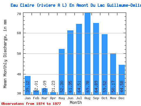
| Statistic | Jan | Feb | Mar | Apr | May | Jun | Jul | Aug | Sep | Oct | Nov | Dec | Annual |
|---|---|---|---|---|---|---|---|---|---|---|---|---|---|
| Mean | 39.11 | 32.28 | 33.08 | 31.23 | 52.29 | 61.35 | 64.50 | 69.77 | 64.89 | 59.51 | 50.17 | 44.58 | 598.04 |
| Standard Deviation | 4.17 | 2.76 | 3.43 | 3.75 | 7.13 | 9.88 | 11.60 | 15.59 | 12.84 | 13.57 | 10.71 | 6.89 | 65.66 |
| Min | 35.00 | 29.11 | 29.36 | 27.51 | 44.10 | 55.53 | 51.39 | 53.09 | 54.62 | 51.39 | 43.54 | 39.35 | 551.61 |
| Max | 43.34 | 34.09 | 36.12 | 35.02 | 57.14 | 72.76 | 73.41 | 83.98 | 82.42 | 75.17 | 62.53 | 52.38 | 644.47 |
| Coefficient of Variation | 0.11 | 0.09 | 0.10 | 0.12 | 0.14 | 0.16 | 0.18 | 0.22 | 0.20 | 0.23 | 0.21 | 0.15 | 0.11 |
 Return to R-Arctic Net Home Page