|
|
|||||||||||||||||
| Point ID: 5146 | Downloads | Plots | Site Data | Code: 03FB001 |
|
|
|||||||||||||||||
| Download | |
|---|---|
| Site Descriptor Information | Site Time Series Data |
| Link to all available data | |
| View: | Time Series | All |
| Units: | m3/s |
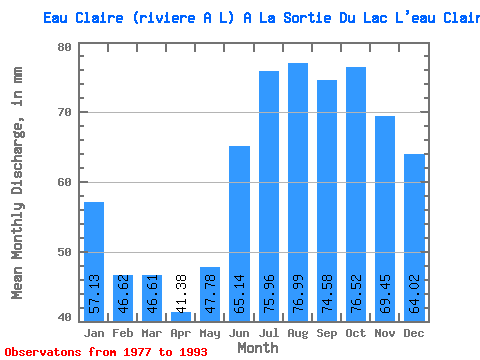
| Statistic | Jan | Feb | Mar | Apr | May | Jun | Jul | Aug | Sep | Oct | Nov | Dec | Annual |
|---|---|---|---|---|---|---|---|---|---|---|---|---|---|
| Mean | 57.12 | 47.02 | 46.60 | 41.38 | 47.77 | 65.14 | 75.95 | 76.97 | 74.58 | 76.51 | 69.45 | 64.01 | 742.44 |
| Standard Deviation | 9.69 | 8.62 | 8.93 | 8.19 | 9.91 | 10.20 | 12.83 | 13.18 | 12.38 | 12.78 | 11.12 | 10.22 | 105.47 |
| Min | 37.55 | 31.54 | 26.85 | 21.32 | 22.59 | 46.76 | 50.27 | 44.89 | 35.94 | 42.65 | 40.06 | 40.06 | 447.51 |
| Max | 76.22 | 62.88 | 60.90 | 54.55 | 60.41 | 79.86 | 92.30 | 101.39 | 92.04 | 99.99 | 88.66 | 83.91 | 860.62 |
| Coefficient of Variation | 0.17 | 0.18 | 0.19 | 0.20 | 0.21 | 0.16 | 0.17 | 0.17 | 0.17 | 0.17 | 0.16 | 0.16 | 0.14 |
 Return to R-Arctic Net Home Page