|
|
|||||||||||||||||
| Point ID: 5143 | Downloads | Plots | Site Data | Code: 03FA002 |
|
|
|||||||||||||||||
| Download | |
|---|---|
| Site Descriptor Information | Site Time Series Data |
| Link to all available data | |
| View: | Time Series | All |
| Units: | m3/s |
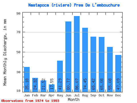
| Statistic | Jan | Feb | Mar | Apr | May | Jun | Jul | Aug | Sep | Oct | Nov | Dec | Annual |
|---|---|---|---|---|---|---|---|---|---|---|---|---|---|
| Mean | 35.17 | 24.53 | 21.52 | 17.55 | 41.28 | 80.77 | 86.06 | 74.44 | 65.42 | 65.07 | 55.08 | 47.09 | 604.14 |
| Standard Deviation | 4.72 | 3.35 | 2.81 | 2.57 | 13.77 | 21.43 | 23.80 | 15.74 | 15.57 | 16.07 | 11.40 | 7.56 | 68.12 |
| Min | 28.71 | 20.69 | 17.42 | 13.11 | 16.52 | 38.57 | 37.49 | 49.70 | 39.81 | 44.56 | 39.81 | 32.35 | 453.33 |
| Max | 42.63 | 29.87 | 28.07 | 24.26 | 62.34 | 136.65 | 133.47 | 115.26 | 91.24 | 106.91 | 85.02 | 63.63 | 736.67 |
| Coefficient of Variation | 0.13 | 0.14 | 0.13 | 0.15 | 0.33 | 0.27 | 0.28 | 0.21 | 0.24 | 0.25 | 0.21 | 0.16 | 0.11 |
 Return to R-Arctic Net Home Page