|
|
|||||||||||||||||
| Point ID: 5141 | Downloads | Plots | Site Data | Code: 03EE001 |
|
|
|||||||||||||||||
| Download | |
|---|---|
| Site Descriptor Information | Site Time Series Data |
| Link to all available data | |
| View: | Time Series | All |
| Units: | m3/s |
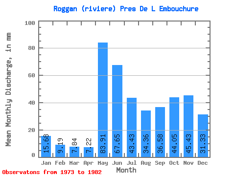
| Statistic | Jan | Feb | Mar | Apr | May | Jun | Jul | Aug | Sep | Oct | Nov | Dec | Annual |
|---|---|---|---|---|---|---|---|---|---|---|---|---|---|
| Mean | 15.68 | 9.27 | 7.84 | 7.22 | 83.90 | 67.65 | 43.42 | 34.36 | 36.58 | 44.04 | 45.43 | 31.33 | 421.75 |
| Standard Deviation | 3.26 | 2.39 | 2.50 | 2.42 | 27.84 | 22.12 | 17.76 | 22.09 | 12.86 | 9.59 | 15.90 | 13.74 | 47.77 |
| Min | 10.06 | 6.02 | 4.93 | 4.28 | 56.02 | 44.47 | 22.41 | 14.09 | 21.61 | 25.49 | 20.96 | 13.64 | 355.35 |
| Max | 19.27 | 12.79 | 11.99 | 10.74 | 128.02 | 97.34 | 75.91 | 67.79 | 58.29 | 54.34 | 72.66 | 55.74 | 498.99 |
| Coefficient of Variation | 0.21 | 0.26 | 0.32 | 0.34 | 0.33 | 0.33 | 0.41 | 0.64 | 0.35 | 0.22 | 0.35 | 0.44 | 0.11 |
 Return to R-Arctic Net Home Page