|
|
|||||||||||||||||
| Point ID: 5117 | Downloads | Plots | Site Data | Other Close Sites | Code: 03DC002 |
|
|
|||||||||||||||||
| Download | |
|---|---|
| Site Descriptor Information | Site Time Series Data |
| Link to all available data | |
| View: | Time Series | All |
| Units: | m3/s |
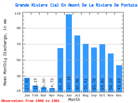
| Statistic | Jan | Feb | Mar | Apr | May | Jun | Jul | Aug | Sep | Oct | Nov | Dec | Annual |
|---|---|---|---|---|---|---|---|---|---|---|---|---|---|
| Mean | 27.91 | 18.34 | 16.00 | 14.73 | 64.98 | 107.18 | 80.95 | 70.40 | 65.72 | 69.79 | 58.10 | 43.68 | 633.58 |
| Standard Deviation | 7.59 | 4.06 | 2.96 | 2.64 | 26.85 | 25.41 | 22.26 | 24.70 | 21.05 | 17.41 | 15.04 | 12.26 | 113.96 |
| Min | 19.04 | 13.39 | 11.22 | 9.88 | 30.62 | 52.54 | 55.01 | 38.00 | 36.29 | 36.91 | 30.26 | 26.06 | 458.69 |
| Max | 51.03 | 29.87 | 23.96 | 19.75 | 135.35 | 147.11 | 147.65 | 123.04 | 108.58 | 97.71 | 91.77 | 76.72 | 834.35 |
| Coefficient of Variation | 0.27 | 0.22 | 0.18 | 0.18 | 0.41 | 0.24 | 0.28 | 0.35 | 0.32 | 0.25 | 0.26 | 0.28 | 0.18 |
| Other Close Sites | ||||||
|---|---|---|---|---|---|---|
| PointID | Latitude | Longitude | Drainage Area | Source | Name | |
| 5123 | "DE PONTOIS (RIVIERE) PRES DE LA GRANDE RIVIERE" | 53.62 | -1049635 | Hydat | ||
 Return to R-Arctic Net Home Page