|
|
|||||||||||||||||
| Point ID: 5115 | Downloads | Plots | Site Data | Code: 03DB004 |
|
|
|||||||||||||||||
| Download | |
|---|---|
| Site Descriptor Information | Site Time Series Data |
| Link to all available data | |
| View: | Time Series | All |
| Units: | m3/s |
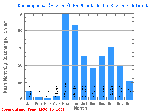
| Statistic | Jan | Feb | Mar | Apr | May | Jun | Jul | Aug | Sep | Oct | Nov | Dec | Annual |
|---|---|---|---|---|---|---|---|---|---|---|---|---|---|
| Mean | 20.22 | 13.35 | 11.84 | 14.95 | 109.83 | 96.48 | 60.95 | 47.04 | 60.31 | 71.11 | 48.94 | 32.18 | 585.96 |
| Standard Deviation | 3.99 | 2.51 | 2.68 | 8.87 | 22.01 | 20.67 | 15.30 | 14.71 | 20.73 | 14.64 | 9.02 | 7.70 | 72.03 |
| Min | 15.69 | 10.08 | 8.60 | 6.70 | 76.14 | 67.53 | 34.45 | 23.05 | 31.95 | 55.30 | 36.99 | 24.09 | 486.02 |
| Max | 28.89 | 17.78 | 17.78 | 35.03 | 147.36 | 142.07 | 85.41 | 77.88 | 99.20 | 109.44 | 65.29 | 50.09 | 708.28 |
| Coefficient of Variation | 0.20 | 0.19 | 0.23 | 0.59 | 0.20 | 0.21 | 0.25 | 0.31 | 0.34 | 0.21 | 0.18 | 0.24 | 0.12 |
 Return to R-Arctic Net Home Page