|
|
|||||||||||||||||
| Point ID: 5110 | Downloads | Plots | Site Data | Code: 03CE001 |
|
|
|||||||||||||||||
| Download | |
|---|---|
| Site Descriptor Information | Site Time Series Data |
| Link to all available data | |
| View: | Time Series | All |
| Units: | m3/s |
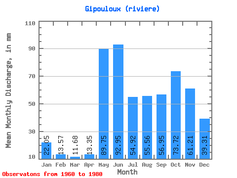
| Statistic | Jan | Feb | Mar | Apr | May | Jun | Jul | Aug | Sep | Oct | Nov | Dec | Annual |
|---|---|---|---|---|---|---|---|---|---|---|---|---|---|
| Mean | 22.05 | 13.68 | 11.68 | 13.35 | 89.74 | 92.95 | 54.91 | 55.55 | 56.95 | 73.71 | 61.21 | 39.30 | 588.52 |
| Standard Deviation | 4.80 | 2.32 | 1.30 | 5.29 | 35.31 | 32.39 | 20.99 | 32.49 | 25.44 | 30.53 | 20.64 | 10.23 | 123.54 |
| Min | 15.32 | 10.58 | 9.40 | 8.95 | 43.69 | 51.76 | 29.86 | 21.33 | 23.24 | 25.59 | 24.62 | 21.96 | 356.95 |
| Max | 31.68 | 18.21 | 14.85 | 30.12 | 167.47 | 182.74 | 126.39 | 157.99 | 100.93 | 144.56 | 103.99 | 59.72 | 812.89 |
| Coefficient of Variation | 0.22 | 0.17 | 0.11 | 0.40 | 0.39 | 0.35 | 0.38 | 0.58 | 0.45 | 0.41 | 0.34 | 0.26 | 0.21 |
 Return to R-Arctic Net Home Page