|
|
|||||||||||||||||
| Point ID: 5108 | Downloads | Plots | Site Data | Code: 03CD001 |
|
|
|||||||||||||||||
| Download | |
|---|---|
| Site Descriptor Information | Site Time Series Data |
| Link to all available data | |
| View: | Time Series | All |
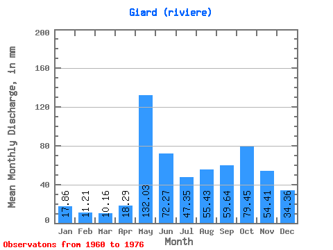
| Units: | m3/s |
| Statistic | Jan | Feb | Mar | Apr | May | Jun | Jul | Aug | Sep | Oct | Nov | Dec | Annual |
|---|---|---|---|---|---|---|---|---|---|---|---|---|---|
| Mean | 17.86 | 11.30 | 10.16 | 18.29 | 132.01 | 72.27 | 47.34 | 55.42 | 59.64 | 79.44 | 54.41 | 34.35 | 592.24 |
| Standard Deviation | 3.72 | 2.00 | 2.04 | 21.39 | 42.59 | 32.35 | 21.67 | 27.20 | 26.85 | 35.50 | 18.50 | 9.72 | 107.08 |
| Min | 12.47 | 8.42 | 5.75 | 4.84 | 57.09 | 33.68 | 24.33 | 18.90 | 20.79 | 26.78 | 20.26 | 21.21 | 422.28 |
| Max | 26.51 | 15.23 | 12.30 | 93.15 | 241.97 | 134.21 | 106.85 | 108.07 | 108.68 | 134.72 | 83.29 | 55.87 | 757.45 |
| Coefficient of Variation | 0.21 | 0.18 | 0.20 | 1.17 | 0.32 | 0.45 | 0.46 | 0.49 | 0.45 | 0.45 | 0.34 | 0.28 | 0.18 |
 Return to R-Arctic Net Home Page