|
|
|||||||||||||||||
| Point ID: 5106 | Downloads | Plots | Site Data | Code: 03CC001 |
|
|
|||||||||||||||||
| Download | |
|---|---|
| Site Descriptor Information | Site Time Series Data |
| Link to all available data | |
| View: | Time Series | All |
| Units: | m3/s |
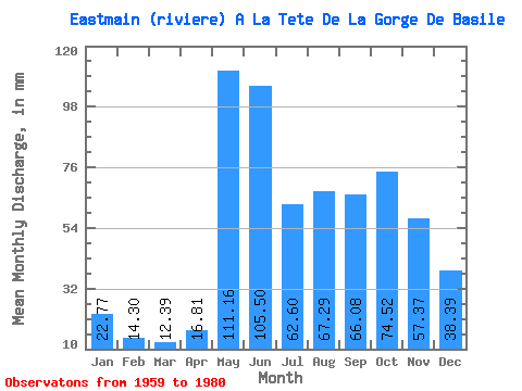
| Statistic | Jan | Feb | Mar | Apr | May | Jun | Jul | Aug | Sep | Oct | Nov | Dec | Annual |
|---|---|---|---|---|---|---|---|---|---|---|---|---|---|
| Mean | 22.76 | 14.42 | 12.38 | 16.81 | 111.14 | 105.50 | 62.59 | 67.28 | 66.08 | 74.51 | 57.37 | 38.38 | 644.63 |
| Standard Deviation | 3.65 | 2.26 | 1.81 | 8.68 | 34.17 | 33.67 | 21.31 | 26.96 | 23.28 | 23.56 | 14.32 | 8.40 | 102.84 |
| Min | 16.26 | 9.97 | 8.52 | 8.37 | 67.71 | 49.97 | 36.15 | 28.96 | 30.07 | 36.51 | 32.94 | 23.82 | 461.70 |
| Max | 30.35 | 19.33 | 16.44 | 41.89 | 188.61 | 196.01 | 126.34 | 132.99 | 126.38 | 129.97 | 90.11 | 55.92 | 821.65 |
| Coefficient of Variation | 0.16 | 0.16 | 0.15 | 0.52 | 0.31 | 0.32 | 0.34 | 0.40 | 0.35 | 0.32 | 0.25 | 0.22 | 0.16 |
 Return to R-Arctic Net Home Page